Naming the Barron
For countless generations the Yirrganydji have called the tidal section of the river ‘Bana Bidagarra’.
In August 1876 John Doyle (1842-1932), William (Bill) Smith (?-1877) and Harry Evans camped on the river above the falls and named it the Silvers River.
On 25 September 1876 Sub-inspector Alexander Douglas Douglas (1843-1914) and Sub-inspector Robert Arthur Johnstone (1843-1905) began cutting a road from Trinity Bay to Thornborough. When they rounded the eastern end of Mount Whitfield they reached the river and named it the Barron River after Thomas Henry Bowman Barron, Chief Clerk of Police in Brisbane.
Shortly afterwards Johnstone, Sub-inspector Townsend and Pilot E W Britain in the Cardwell pilot cutter and William Bairstow Ingham (1850-1878) in his stern-wheel paddle steamer Louisa sailed along the coast from Trinity Inlet searching for the mouth of the Barron. Both vessels crossed the bar at the river mouth and sailed upstream to the shingle bar that prevented further access. Leaving the boats they continued upstream on foot and entered the Barron Gorge.
History of the area
The discovery of gold on the Hodgkinson River led to the development of the settlement of Thornborough. Access to Thornborough was via a lengthy track from Cooktown, Cardwell or Etheridge and there was a need for more direct access to the coast. Towards the end of June 1876 John Doyle (1842-1932) along with William (Bill) Smith (?-1877) and Mr [John ?] Cardno reported seeing the sea while out prospecting. Smith believed it was Trinity Bay they had seen from the top of the range as he recognised it from his time harvesting beche-de-mer on Green Island. Cooktown magistrate and Warden of Thornborough Howard St George (1817-1889) reported Doyle’s efforts to the Department of Mines (Queenslander, 5 August 1876).
Discussions in Thornborough resulted in several parties departing to look for a way down the range and through the coastal scrub to Trinity Bay.
Smith’s Track
Doyle and Smith set out from Thornborough again, this time with Harry Evans. On Tuesday 15 August 1876 they camped near today’s Kuranda on a river they thought might be the Mulgrave. However as they made their way down a spur on the range to the coastal flats near Kamerunga, Doyle realised that it wasn’t the Mulgrave and he named it the Silvers River. Doyle returned to Thornborough without reaching the sea; the last eight miles of thick coastal scrub stopped his progress. On reaching the settlement his report of the Silvers River was met with ‘derision’ as the mouth of the this river, which Douglas and Johnston would later re-name the Barron, was not marked on any charts and had not been reported by any of the coastal vessels. Mulligan thought this river was the Mitchell and Doyle’s Silvers River was known as ‘Mulligan’s Mistake’ (Jones p.61).
Bill Smith continued on to Cooktown and hired a cutter. With John Mackay, Joseph Brown, John Manly, Chris Lipton and two Fraser island Aborigines they sailed into Trinity Bay and up the inlet to Smith’s Landing, arriving 1st September 1876. After spending some time negotiating the swamps Smith reached their former track at the foot of the range where he had been with Doyle a month earlier. Before ascending ‘Smith’s Track’, Smith sent the boat back to Cooktown and then he, Stevens, MacKay, Lipton and the two Aborigines climbed the range and arrived at Thornborough on 21 September 1876 (Jones p.68).
Douglas’ Track
At the same time as Smith was exploring the range the government had instructed Sub -inspector Alexander Douglas Douglas (1843-1914) who was in charge of the native police camp at Thornborough to find and blaze a track from Thornborough to Trinity Inlet. Douglas left Thornborough on 17 September 1876 with government surveyor Frederick Warner, his brother Charles Warner, Mr Williams, Constable McDermott and six Aboriginal troopers. They reached Trinity Bay on 23 September 1876 on a route that descended the range slightly to the north of Smith’s Track. This alternative route was known as Douglas’ Track. At Trinity Bay Douglas met Sub-inspector Robert Arthur Johnstone (1843-1905) who had been instructed to sail from Cardwell to offer assistance. Johnstone with Sub-inspector Townsend and nine troopers sailed with pilot E W Britain in the pilot cutter.
Naming the Barron River
On 25 September 1876 Douglas and Johnstone commenced cutting a road from Trinity Bay to Thornborough heading through the swamps and then around the eastern end of Mount Whitfield. Douglas reached the River the Yirrganydji called Bana Bidagarra and which Doyle had named the Silvers River.
Douglas continued up to the top of the range where a group of Thornborough miners were camped waiting to take up land at the new port at Trinity Bay. Johnstone and Townsend returned to the boat and sailed up the coast to find the mouth of the Barron. While in the bay he met William Bairstow Ingham (1850-1878) in his stern-wheel paddle steamer Louisa. They both sailed up the Barron as far as possible and then walked up as far as Caravonica. (Accounts of Douglas & Johnstone, 7 October 1876 Queenslander, Johnstone’s official report 21 October 1876, Queenslander).
Once the river had been explored they returned to Trinity Inlet. On the return journey Johnstone decided to name the river after the Chief Clerk of Police in Brisbane, Thomas Henry Bowman Barron.

Paddle steam ship, Louisa, 1880s.
Image: State Library of Queensland
Smithfield
Both Smith’s and Douglas’ Tracks were steep and difficult to ascend. Packers favoured Douglas’ Track but an easier route was needed over the range. A C Macmillan, engineer in charge of roads, and Charles MacDonald, northern roads engineer, arrived in Trinity Bay in mid-October 1876 and after surveying Smith’s and Douglas’ tracks declared both of them unsuitable as dray roads.
Frederick Warner discovered an alternative route which climbed a spur of the Macalister Range some three miles to the north of Douglas’ Track. Four men, who were probably Macmillan’s road crew, Billy Lane, Redmond, Sweeney and one other, also claimed to have found an easier route on the Macalister range three miles north of Douglas track.
Macmillan’s four-man road crew set up camp on the south bank of the Barron River near Kamerunga. Packers moved from the new port of Cairns to the foot of the range and set up a camp with a store and public house near the road crew’s camp. Warner surveyed a township on the north bank and on 15 December 1876 the town of Smithfield was gazetted.
Establishing river traffic
Goldfields Warden Howard St George (1825-1897) and Warner travelled up the Barron in Ingham’s Fitzroy to inspect the new township with Charles MacDonald and Bill Smith. A naming ceremony was held with speeches and toasts made with champagne and soda-water. All carriage into Smithfield was by boat along the Barron, the first supplies arriving in a boat owned by Carl Frederick Ahnstrom Sparre. Ingham soon established a daily service using the Louisa and Fitzroy, and Smithfield grew rapidly to be the main settlement in the north. Although Smithfield’s dominance was only to last a short time its position ensured the Barron River became an important trade and transport route.
SS Dugong on the Barron River
Brisbane Courier, Monday 12 March 1877, p.3. Article titled ‘Progress of Settlement at Trinity Bay’, dated Cairns, 28 February 1877.
The fact that some strangers had purchased allotments at Smithville, and were anxious to inspect them, and that there were many people in town bound for the Hodgkinson, decided the ASN Company’s agent on, sending the SS Dugong up the river on a second trip (as I informed you she had previously made a very successful trip).
This vessel is of 62 tons register, 16 horse-power, and licensed to carry 250 passengers when engaged in harbor or river navigation, and 30 when employed in sea-going voyages, and is commanded by Captain Gemmel, a gentleman of long experience on this coast. On this latter trip she left the wharf at Cairns at 11.15, crossed the bar [at the mouth of the Barron] in 8 feet of water at 12.25, but when about half-way up to Smithville stuck on a sandspit, formed by the rush of water from a creek running into the river at a right angle, and, as the tide was falling at the time, all efforts to get her into deep water proved of no avail, and we were obliged to reconcile ourselves to the situation, the captain and officers doing all they could to make things comfortable. In spite of the disagreeable rainy weather which prevailed all the afternoon, some of the Smithville passengers whose business was most urgent were taken up in the ship’s boat.
The steamer floated about 8 p.m., but the rain was so incessant and the night of such pitchy darkness that the captain determined on waiting for the morning tide, and when that answered we left our moorings, and without further mishap arrived at the Smithville wharf, where the remaining passengers, several horses, and a quantity of cargo were disembarked; and leaving with the same tide we steamed down the river, but did not reach the bar until more than half the ebb-tide had gone. So we again grounded; and I may here state that during the detention on the bar the officers and crew of the ship thoroughly surveyed at, and found that there exists a narrow channel of sufficient depth to admit of its being used by vessels of larger draught than even the Dugong, drawing 6 feet 6 inches. But the entrance should be marked as well as the whole channel up the river to Smithville. This could be easily and inexpensively done; in fact, the chief officer of the Dugong, and other experienced men with whom I have conversed on the subject, are of opinion that the work could be performed in a couple of days, and I have no doubt but that Harbor-master Spence and Pilot Mylcrist only require instructions from the ‘powers that be’ to add another laurel to the wreaths they have already earned here; for all the navigators of these waters speak in the highest terms of the admirable manner, in which the harbor channel has been buoyed and marked by beacons, and also of the serviceable disposition of the night lights ; in referring to which latter I may remark that the thanks of the public are due to Captain Heath for the promptitude with which he complied with Mr. Spence’s request that these valuable adjuncts to a system facilitating safe harbor navigation should be allowed for this port.
Robert Arthur Johnstone (1843 – 1905)
Information from: http://adbonline.anu.edu.au/biogs/A040550b.htm

Sub-inspector Robert Johnstone.
Image: State Library of Queensland
Birth: 1843, Richmond, Van Diemen’s Land (Tasmania), Australia
Death: 16 January 1905, Toowong, Brisbane, Queensland, Australia
Cultural Heritage: Scottish
Religious Influence: Anglican / Presbyterian
Occupation: explorer / magistrate / police officer / sugar cane farmer.Robert Arthur Johnstone (1843-1905), explorer and police officer, was born at Richmond, Van Diemen’s Land, youngest of the six sons of John Johnstone, grazier, and his wife Annie Elizabeth, née Meed. His grandfather was George Johnston. The family moved to Victoria in 1851. Like his five brothers and a sister, Robert was sent to Scotland for education. He returned to work with stock in Queensland in 1865 and for a time managed Apis Downs. In April 1867 at Landsdowne, Mackay, he married Maria Ann Gibson, who was born on 30 November 1847 at Watson’s Bay. A Presbyterian, Johnstone attended the Church of England after his marriage.
In 1868 Johnstone became manager of the first sugar plantation at Bellenden Plains, about twenty miles (32 km) north of Cardwell, for Trevillian & Co. It changed ownership in 1871 and Johnstone, who trained as a cadet at Fort Cooper, was appointed sub-inspector of native police to the Cardwell district. Cardwell was then Queensland’s most northerly port. In the 1870s northern frontiers were rapidly expanded by gold discoveries and exploration, and the increased European activity on land and sea was accompanied by significant increases in Aboriginal hostilities.
Settlers, bushmen and shipping, disabled or not, were attacked while massacres, cannibalism and surreptitious murders were reported often. Johnstone’s patrols, punitive or otherwise, took him beyond Trinity Bay and west of the ranges, and were interwoven with the accounts and reports of such hostile activities as the wreck of the brig Maria (1872), the Goold Island murders (1872), the Green Island massacres (1873), the attack on the Albert and Edward (1874), the Conn murders (1875), the Dunk Island murders (1877) and the Riser wreck and massacres (1878). Rather anonymous complaints of the extremity of measures taken by Johnstone against the Aboriginals who killed and ate the captain and crew of the Maria reached the Queensland parliament. Politicians were satisfied by Johnstone’s denial and Cardwell people, more aware than suburban dwellers of the risks Johnstone faced for their protection, presented him with a testimonial of appreciation with particular reference to the wreck of the Maria: the original is now held by the Johnstone Shire Council.
In charge of native police Johnstone in 1873 accompanied George Elphinstone Dalrymple on the north-east coast expedition to explore the coastal lands as far as Cooktown. Mounts Annie and Arthur in the Seymour range were named after members of Johnstone’s family and Dalrymple named the Johnstone River after him; he had first found it when investigating the Green Island massacres. On this expedition he climbed Mount Bellenden Ker, not Bartle Frere, a supposition which has led to controversy and counter claims. In 1876 he discovered and named the Barron River when searching for a route over the ranges behind Trinity Bay to serve the new goldfields. With this route found, Cairns was begun with his assistance. In 1879 he escorted James Tyson over the Tully River lands which led to their selection, and Thomas Fitzgerald to the Johnstone River lands which led to the beginnings of Innisfail. He briefly tried grazing on the Herbert at his property Molonga but soon rejoined the public service. In 1881 he took his family in a dray to Winton where he became the first police magistrate and conducted its first land sale. He was transferred to Bundaberg in 1882 and to Howard and Tiaro in 1887. He lived at Maryborough in 1890-1900 and then moved to Beenleigh. He was living at Toowong when he died on 16 January 1905. He was survived by three sons and four daughters of his nine children.
Sometimes known as ‘Black’ because of his tan, or ‘Snake’ because he often teased children by producing snakes from his shirt, Johnstone was a keen naturalist and observer of the flora and fauna in northern scrubs. His reminiscences of North Queensland appeared as ‘Spinifex and Wattle’ in the Queenslander, 1903-05. These articles emphasize the things of nature which delighted him on his patrols. A freshwater crocodile and species of freshwater turtle are named after him.
Select BibliographyG E Dalrymple, Narrative and Reports of the Queensland North-East Coast Expedition, 1873 (Brisbane, 1874);
Dorothy Jones, Cardwell Shire Story (Brisbane, 1961).
|
This Stratford Heritage Trail sign was made possible thanks to the generous sponsorship of:
|
|
|
Steve Wettenhall MP, |
|
Download and Print the map
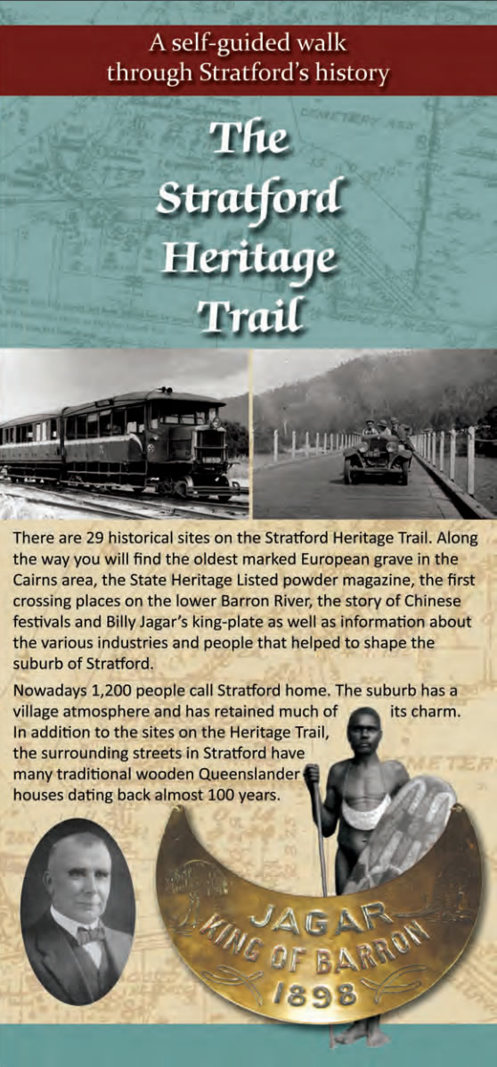
The Stratford Heritage Trail is an initiative of the
Stratford & Freshwater Community Association